Tuesday, October 3, 2023

Finding An Ancestor's Land On A Map/ a challenging process

When I visited Virginia and Tennessee this past July and August I wanted to visit the location of my ancestors' land. I had descriptions of the approximate location because creeks were mentioned in their deeds. Since creeks can run for many miles it's difficult to say where, exactly, their land was?

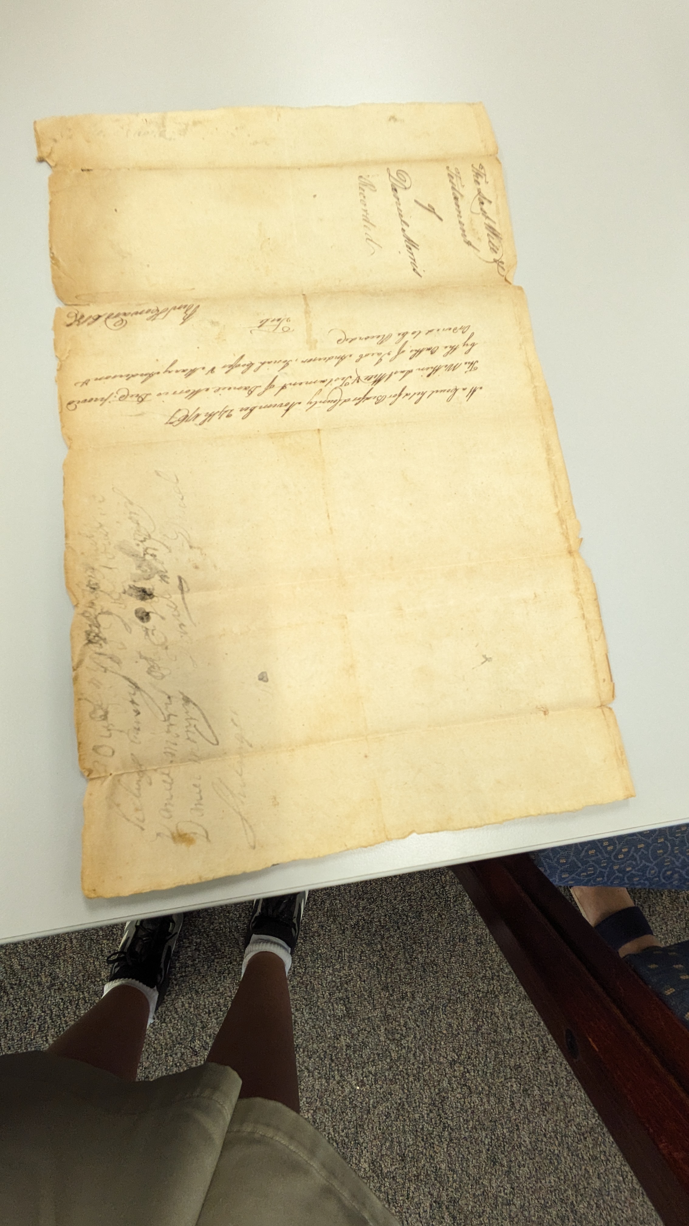
Virginia does have county historical maps that were produced by a cartographer. These maps show approximate locations of early settlers' land. They were produced by H. R. Hildebrand. My ancestor Moses Wray is listed in the Franklin County. Virginia map. I wondered what the source for these locations were? I did some research in the courthouses and didn't see any information there pinpointing land locations? I did find a description of what the sources were at the East Tennessee State University website. "Compiled from old maps, historical records, and traditions by J.R. Hildebrand." The fact some of the locations were based on traditions worried me a little. I had taken these maps more literally. I now felt like I needed to verify the approximate location, also. 


I visited a surveyor's office in Rocky Mount because I thought they might have some tips regarding locating an ancestor's land. The office had some hunting trophies (which reminded me of my grandfather Forgey who liked to keep taxidermy animals).   


The surveyor's suggestion was to trace the land ownership forward using deeds. Once the current owners information is found the exact location of the land can be found using tax records. 

I attempted to trace the land forward using deeds, but quickly lost the ownership trail. Could be later owners didn't file deeds? I wasn't sure why I was having problems? I decided to try to trace the land ownership backward instead. 

So how do you find current land ownership information? The best way is to use a parcel land viewer. There are many of these online and free to use. Franklin County, Virginia's parcel map is located at the ArcGIS Franklin County, Virginia website

Moses Wray owned land on Maggodee Creek and White Oak Creek in Boones Mill. White Oak Creek on Google Maps is mismarked Gills Creek. That creek runs east west whereas White Oak creek runs more north south and eventually meets the Blackwater River. 

The most accurate topo maps are on the USGS website. They have maps showing creeks going back to the 19th century right up to the present. I was thinking the name of White Oak creek changed when I didn't find it on Google Maps. That slowed my progress locating the land. 


What I know from the deeds is Moses Wray had land on Maggodee Creek and White Oak Creek. using the USGS map I found the creek. Since White Oak Creek flows into Maggodee creek  I guessed the land is in that area. 

Now I had a general location to search the parcel map at ArcGIS. My hope was actually to find someone with the surname still owning the land in the area, but I was thinking I would likely have to trace the many parcels backward. 

Clicking the first few parcels I didn't see any surnames I recognized.  To my surprise I did click on a parcel owned by someone with the surname Wray! I've decided to contact this current Wray owner and ask if he knows whether Moses Wray owned his land. They'll probably think I'm crazy but the worst that could happen is I don't get a reply. 

If you look at the blue outline of the land currently owned by a Wray it gives us an idea of how much land the family once owned. The current owner owns 86 acres. The Wrays owned hundreds of acres in this area. Their land would have covered a substantial amount of land on White Oak Creek. That creek is shorter than Maggodee Creek. 


Now that I have a better approximation of where the Wray land was, how accurate is the H. R. Hildebrand map? Since there is no scale on this map it's tough to say. Hildebrand did have Moses Wray's name written on the correct side of the highway. Comparing where the current Wray land owner owns land Moses Wray's land would have been about 3 miles east of the highway. The Hildebrand map is generally right but would give some people the false impression Moses Wray's land was closer to the highway and farther north than it likely was. 


The current Wray landowner, on White Oak creek, owns parcel 7. Two of Moses Wray's sons inherited what they called lots 4 and 5. I wonder if two other sons inherited lots 6 and 7? I have no idea whether the numbering is the same? 


Moving on to Tennessee I wasn't so lucky. I'm looking for ancestor Hugh Forgey's land. Unfortunately the Forgey family didn't stay in the Corryton, Knox County, Tennessee area. Since Hugh Forgey's land was described as being at the head of Little Flat Creek I have a general idea of where the land was located. I tried to again trace parcels backward and forward to get the exact location of the land. The Forgey land was probably broken up into smaller parcels, and I haven't been able to establish the exact location of the land. Hugh Forgey owned 300 acres of land. The current owners in the area own much smaller parcels of land. The map outline, below, shows 7 acres. Hugh Forgey's land would have covered a large portion of the Little Flat Creek area. 


The online parcel maps showing current landowners has been helpful when it comes to finding the names of current landowners, and viewing  how the land has been broken up into smaller parcels. Great tool for genealogists! 


Wednesday, September 20, 2023

Research Trip Serendipity


I took a trip to the Virginia Piedmont area and East Tennessee in August. My Wray and McPike ancestors were from the Piedmont area of Virginia. I started my journey in Lynchburg where I visited the Jones Memorial Library which is a genealogy library.

Traveling around Lynchburg was easy. The city has a bus system, it’s pretty limited but cheaper than renting a car or using Uber or Lyft.


From Lynchburg I moved onto Franklin County, Virginia. I took a Greyhound bus from Lynchburg to Roanoke (I found out train service was also available and I probably should have taken the train). Roanoke being a city it was easy to get a Lyft to my hotel in Franklin County. 

I arrived in Rocky Mount on a Saturday. I was told by the front desk person at my hotel that there was no public transportation, Uber or Lyft. The one car rental agency was closed until Monday. I wanted to travel about 12 miles to Boones Mill where some of my ancestors lived. I decided to try to schedule a Lyft for Sunday morning.

A Lyft driver did pickup the ride. I believe they picked it up because the wrong pickup location was given to them. I received a message that the driver had arrived, but didn’t see him? I called to ask where his car was. We then discovered he was about 20 minutes away from me. He agreed to pick me up anyway. If he knew I was farther away he probably wouldn’t have picked me up.

Talking to him on the way to Boones Mill we discovered we had a mutual interest in visiting cemeteries. He agreed to take me to cemeteries, and other places of interest, if I paid cash for his gas.


I had worried about getting back from Boones Mills. He agreed to come back and pick me up later. If he hadn’t picked me up I would have called a taxi in Roanoke, and it would have cost a fortune and there would be no guarantee they would pick me up.


Since the driver knew the area I saw more of the area than I would have on my own. He has family living in Boones Mills. I didn’t lose any precious time waiting to rent a car and didn’t get stranded somewhere without the ability to get back. When I was in Lynchburg I visited Poplar Forest, but couldn’t visit the town of Bedford without a car. I wanted to do some research there. The Lyft driver took me to Bedford where I was able to see and hold an ancestor's 1767 will.


I also met a friend of the Lyft driver who is distantly related to me. She knew quite a bit about our shared Wray family. 

When I went on to Knoxville, Tennessee I was able to get around easily using buses, and walking. I decided to visit the rural area where my Forgey family came from one day. Like Roanoke it was easy to get a Lyft to the Corryton area. I worried a little about getting back. I again figured I could call a taxi if worse came to worse.

It seemed the easiest to set my ride destination as the Nicholas Gibbs log house. I had been wanting to take a closer look at that house after reading about an archaeological dig there. Also my ancestor Hugh Forgey was acquainted with Nicholas Gibbs because Gibbs posted a bond for Hugh. The Lyft driver had difficulty finding the log house. We did finally find it. The house is operated by the local historical society. I was just going to look in the windows, and then walk around the area where I believe my family’s land was.

There were phone numbers on one of the windows. I decided to call and ask if it would be possible to go inside the house? By chance one of the volunteers was in the area and came right over and showed me around.


As I did everywhere I went I asked if the volunteer knew anything about the Forgey family? He said absolutely. He found a trunk full of papers in an old house in the area and there were a few documents with the surname Forgey. He told me most of the papers were now at the Calvin M. McClung Genealogy Library in Knoxville. I had been there several times and didn't know about that special collection. I planned on returning to that library later in the day.

The volunteer, Mr. Longmire, was very nice. He offered to take me around in his truck and show me the area where my ancestors lived. Again I lucked out. It was very hot and humid and would have been difficult for me to walk very far. Actually the area where my family's land was turned out to be farther from the Gibbs house than I thought. It was about 3 miles away. He also took me to the Sawyers house where the many of the papers found in the trunk were originally stored. They were actually moved to the McBee house, which he also showed. A Sawyer's daughter married a McBee. These families were related to the Forgey family by marriage.


Mr. Longmire also showed me his collection of genealogy material at his house. I also met his wife, and dog. He left me off at a Target where I was able to get a Lyft back to Knoxville, that was ideal. I couldn't believe my luck meeting up with him!

I spent 2 days going through the McBee/Sawyers papers at the Calvin M. McClung collection. There were documents naming Forgeys, and Civil War letters that were fascinating.


In hindsight, not renting a car for this journey turned out to be a blessing in disguise. The challenges I faced led to unexpected encounters, deeper insights, and a richer understanding of my ancestral roots. My trip reinforced the notion that on a research trip, the more people you engage with, the more you are likely to learn.


I also attended the all day History Hootenanny during my trip, which included historic home tours


Tuesday, July 25, 2023

My Wish Has Come True For An Every Name Index to Deeds at FamilySearch!


United States Wills and Deeds Experimental Search

What have I been wishing for years now? An every name index for deeds! I've been hoping for this for ages, and guess what? FamilySearch made my wish come true with their new OCR search that works as an every name index. How awesome is that?

It actually also is a will index, and brings up other types of records too. 

It's about as accurate as the old newspapers indexed with OCR.  It can be a bit hit and miss because of messy handwriting and fading text. But hey, no system is perfect!

Also if your ancestral area prohibits FamilySearch from making their records available from anywhere you won't be able to see the actual documents, unless you visit the FamilySearch Library or a Family History Center. As you can see below one search result brought up one blank document. 


The second result, brought up by my surname search, did return an actual document. You can click on the transcript to see a transcribed copy of the document or just view the actual image of the original document. 
 

When you do view the original documents pages sometimes your search names are surrounded by red dotted lines, which are helpful. 


Oddly, sometimes, you can't turn the pages once you're on the image. That's a problem if your document is multiple pages. Also, these limited pages, don't have additional information so you can find the microfilm in the catalog. Most pages do, however, allow you to turn the pages and provide information about the source. 

If I don't find what I'm looking for with one search, I brainstorm!  I just tweak the search a bit. I was looking for a deed related to my several times great-grandfather, and at first, I couldn't find it. I then searched using his wife's name instead and it came up! 

I've been researching my family history for over 20 years and still I've found new information using this search. 

For instance I found a brief will for a 3 times great-grandfather. In all these years I've research I missed it somehow? 


One piece of information scared me. I worried I identified the wrong family for my ancestor Nancy Melvin-Hicks. When searching for Nancy Melvin I found a will for James Blades. He  said his sister was Nancy Melvin. I wondered if my Nancy Melvin married before and I was wrong about her parents being John Melvin and Mary Redden. Actually when the will was written my Mary Redden was married to Elijah Hicks. 


I wanted to make sure so I researched this other family. I figured Melvin would have been Nancy's married name. I searched for a Melvin marrying a Blades and only found someone marrying after the will was written. I finally discovered Nancy Melvin was married to William Melvin and it was her second marriage, that's why I couldn't find a Blades/Melvin marriage before.


I've paged through countless deed books in my quest to learn about my ancestors. I don't have all the time in the world to go through hundreds of books from my ancestral areas. That would take forever! It would probably take indexers a lifetime to create every name indexes for all those deed books. That's a massive task!

So, a big thank you to FamilySearch for this innovative OCR search feature. It might not be perfect, but it's definitely a step in the right direction. 


Friday, July 21, 2023

How My Segment Map Has Helped With An Irish Match

A new DNA match popped up at 23andMe with the surname Rattigan. This person lives in Ireland. This could refer back to my Huane/Rhatigan line? The only information I have about the maiden name of a great-great-great grandmother comes from a pension application with information from the 1851 Census. My great-great grandmother and her brother applied for pensions. The applications states the maiden name of their mother was Rhatigan. I haven't found any other information to support that. My new DNA match may confirm my great-great-great grandmother was Bridget Rhatigan?


My new Rattigan match shares one 7 cM segment and one 28.46 cM segment. Sharing 2 segments leads me to believe this is a valid match, as does the person's paternal line is from County Mayo where my Rattigans would have lived. Checking Genome Mate Pro segment map I don't have any named segments on the 7 cM chromosome. 

I do have a portion of chromosome 21 identified as coming from my Irish Mullen/Huane line. Unfortunately I only know that a couple matches on that chromosome are of Irish heritage but don't know exactly who our common ancestors are? One lives in Australia. I live in the United States.


Using my segment map I noticed the Australian match and the Irish Rattigan match share the exact same segment, along with another person. 


Unfortunately, I'm the only descendant of the Rattigan line who has tested at 23andMe. My aunt, who tested at Family Tree DNA, would be a better person to compare with this match. Fortunately I have the Genome Mate Pro segment map. Looking at the map I notice I do share a segment with my aunt on chromosome 21 where my 23andMe match and Australian match also do.


I have that segment on my aunt's chromosome 21 identified as coming from a descendant of Thomas Huvane/Huane. The wife of Thomas Huane was Bridget Rhatigan according to the pension information. 

At this time this match seems to be pointing to the Rattigan/Huane line of County Mayo, Ireland. We have the match stating her paternal line was from Mayo, I have segment map data confirming segment chr 21 is of Irish origin, and my aunt has a confirmed Huvane/Huane match on segment 21. 

Since I have matches who haven't tested at every site, plus most of my matches on my Irish line have no posted trees, DNA segment data is very important. The reason they don't have trees is because most of the church records in the area where our ancestors lived have been destroyed. We need DNA and the segment information to try to piece our family trees together. I've contacted the match at 23andMe, but most matches never reply. Fingers crossed they do. 


Sunday, April 30, 2023

A Trip to the Past: Identifying places in old photos


Google Street View has been a useful tool for me to identify the location of some of our old family photos. However, it didn't help me identify the school in Glendale, California, where my mother posed with her Girl Scout troop. I've always been fascinated with this particular photo, as my mother loved her Girl Scout troop and their energetic leader Bunny. Bunny even led the girls on a hike up to the Griffith Park Observatory!

They were dressed as Circus performers. One of the wagon in front belonged to my mother's family.

I recalled seeing a street number on the building in the photo, but I didn't think to look at a city directory. Fortunately, someone on Facebook helped me identify the school as Columbus School. This person used a city directory to identify the school. 


Upon further research, I discovered that Columbus School was founded in the 1890s with only 30 students, and has been rebuilt and added on to multiple times since. The buildings in my mother's time dated back to the 1920s, but the school was rebuilt again in 1949 and no longer bears any resemblance to the school my mother attended in the 1930s. Therefore, Google Street View would not have been helpful in this case.

I was also unsure where a mission photo was taken. My mother's family often visited both the San Gabriel Mission and the San Fernando Mission, but I wasn't sure which one it was. I visited the San Fernando Mission for the first time yesterday and confirmed that it was the one in the photo. I could have used Google Street View or online photos to identify the mission, but it wasn't necessary in the end.

Old family photo of the San Fernando Mission

Taken yesterday


Taken yesterday

The Forgey family, my mother's family, frequently visited the mission in the 1930s when they lived in Glendale. My mother particularly loved Brand Park, which is located across the street. During my recent visit to the San Fernando Mission, I was unable to walk around the park due to Quinceañera photo shoots, but I still enjoyed the beautiful gardens there.


On a side note, Bob Hope and his wife Dolores are buried in a garden at the mission. 


As I walked around the mission grounds, I felt a deep connection to my family's history in California. It was a poignant reminder of the memories and stories that have been passed down through the generations, and I feel grateful to be able to continue learning about and exploring my family's past.