I'm leaving in a week for a trip to the ancestral homeland of Ireland. I will begin my trip in Dublin, then head south and west, doing some sightseeing, and then ending my trip by staying a few days in Tuam, Ireland (before heading back to Dublin for one more day before my flight). From Tuam it's an easy drive to Milltown, where my family attended church, and Pollaturick the ancestral townland (I'm not sure whether I will make it to Kilvine and Irishtown in Mayo on this trip?).
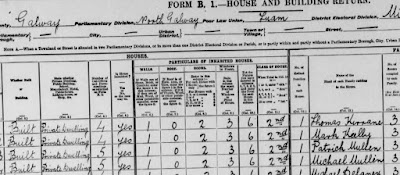
Since I know the townland and the section number of the property on the Griffith's Valuation Map I can visit my family's land and home in Pollaturick. I thank my cousin Darryl Kapple a million times for finding a listing for our Mullen family's home in this townland.
Here is the listing he found:
Patrick Mullen Sr. can be found on Griffith's Valuation in the mid- 19th Century renting the land which is section 1 on the map for the valuation. He was renting all of the land outlined in the bottom left corner. After land reform the family was allowed to purchase the land, which they did. My great-great grandfather Patrick Mullen Jr. divided this land with his brother Michael. You can see a line dividing this land in two. Later they divided this land between their heirs.
A problem I had to resolve for this trip was I didn't have an address for this land and house. I used Google maps to find Pollaturick. A map for the area did come up but the area is marked as Bohalas, not Pollaturick. A red tack for Pollaturick shows up on the far left side of the townland. I will have to ask if there was a name change or this is an error on Google's part?
With the map possibly being wrong I had to figure out where the boundary lines were. I started by looking for another map with the townland borders. The Ask About Ireland site, which has a Griffith's Valuation database, has the best townland maps. Flipping between those maps and the satellite map I was able to see that the outline of the townland can still be seen from above. The outline of my ancestors' property can still be seen also. The lines are still visible but are fading.
From the air you can see the house that is now for sale (on the right below). Street view doesn't show a view from that smaller road. There are views from the main road however.
From the air you can see another ruined building (⇫ above far left highlighted) on the property which I might examine if it isn't too difficult to get to? From what I've heard there is a lot of barbed wire fencing in the area. There is a garden center not far from there so I may be able to buy wire cutters?
Here is a street view of the other ruined building, which was likely another house, on the property. It does look like there were two houses on the property, one belonging to Michael and the other Patrick. There was also a building called an office.
Street view does show one building, and possibly more on our Mullen land. This building below is on Mullen property. The house for sale can be seen in the distance.
It's possible that these buildings from Google street view belonged to the Mullens? I will knock on the door of the house near them and ask.
I want to take a look at the old train station and signal house in Pollaturick. Believe it or not a Pierce Brosnan was station master there back in 1911. If anyone knows if he is related to the actor please let me know? This Brosnan appears to have relocated to Pollaturick to work for the railroad.
Oddly the railroad station house is said to be in section 15 according to the Valuation Revision Books. I can't find a map with a section 15? I did find a map with a crossed out 12 changed to 14.
Cross outs often signified changes in ownership in the cancelled books, so that may be the case on the maps also? Below you can see Patrick Mullen 1A crossed out. New sections A and B, C and D, are created to divide the land between the brothers.
All of this information will make my trip to Pollaturick fruitful. I worried about getting lost but now I know the area very well and don't think I will get lost.
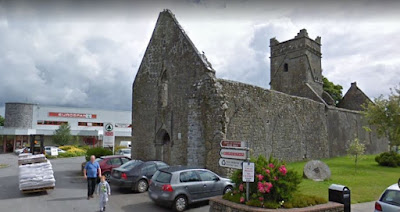
I might travel a little farther afield and check out some ruins close by, such as Dunmore Castle. I found a ruined monastery not far away which is in the parking lot of a Superstore. With all the empty land why build a Superstore on top of a nice ruin? As my Irish family would say Jesus, Christ, Mary, and Joseph why? Maybe this is a Protestant business? There were Irish Protestants on my mother's side of the family, my father's side is this Pollaturick Catholic Mullen/Huvane family. On the Catholic side we blame everything on Protestants lol.
I'm more than ready to be heading to Pollaturick. I'm hoping the first week doesn't fill my head to over flowing with information that I forget where everything is in the townland. I'll have to make a copy of everything so I don't forget. I'm also making some copies of family pictures to share, and hopefully stir up some local interest in helping me to rediscover my Irish ancestors history (below is a picture of Helen Mullen-Mason my great-grandmother with her son and granddaughter. She was born in Pollaturick and came to America, Chicago, in 1898. She was the daughter of Patrick Mullen Jr.. Both of her parents remained in Ireland until they died in the 1930's).


