Wednesday, May 29, 2024

Update: All Farmhouses Look Alike / and new Tabitha Wray information

Update from last post: I discovered looking more closely at the house I thought may have been in a photo shared on Ancestry.com, as a Moses Wray house, that it doesn't match the house in the photo. I knew it wasn't his house, he would have lived in a log house, but thought it could have sat on his land. 

The only house I could find similar to that house, using Google Street View, compared more carefully, can't be the same house in the old photo. When I looked at Google street view from another angle I could see the house didn't have 3 windows on one side. It has only one window on the side. 


Posting about my mistake on Facebook several people identified the house in the photo as being a house on Poff Lane. The house was at one time owned by a Wray family, but the original owners of the house and property were Wrights. This 1906 built house was constructed around a log cabin, likely belonging to the Wrights, sometime before the Civil War. 


Looking more carefully at the Inn it doesn't have 3 windows on the side of the house. The second floor of the house was destroyed by fire and rebuilt. I suppose windows may have been removed when the house was remodeled? An old photo taken in the 50s or 60s also shows only two windows, however I don't know which side of the house the photo was taken on? Also the slope of the land, looking at the right side of the photo is different. 

Someone would have to verify the house in the photo on Poff Lane is the same house. It may not be. Many farm houses were built just like these. The house in the photo may have been torn down, or remodeled? I think we are learning which houses are not the house in the photo. 

Old photo


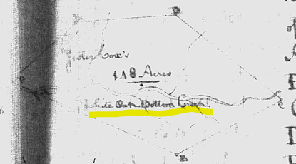
What we do know is that Moses and Elizabeth Wray owned property on both sides of White Oak Bottom Creek, north of Maggotty Creek. 

Some unanswered questions about the location of their land. Is White Oak Bottom Creek the same as today's White Oak Creek? Has White Oak Creek always followed the same course? Water can always change course and people sometimes change its course. What we do know is the creek existed as early as 1755 when Jester Cox made a survey on that creek. 


Moses and Elizabeth also own land on Maggotty creek. So I'm figuring their land on White Bottom Creek was likely near where White Bottom Creek emptied into Maggotty Creek? 

New Wray Information

I've questioned whether Moses Wray's wife Elizabeth Morris could have been the mother of all 18 of his children. That seems to be more children than possible for one woman to give birth to. It is possible though. It's happened, but not frequently. My ancestor Benjamin Wray was one of Moses Wray's oldest children. So was his mother Elizabeth Morris? 

Robert Grant shared some of his research with me. His research, on the Wright family, can be viewed at FamilySearch. Sorting some of the Wrights of Southern Virginia : part III, 1809 William Wright of Franklin County, his wife Mary (Grant) Wright and his descendants Sorting some of the Wrights of Southern Virginia by Robert Grant contains information about many associated families. 

My ancestor Benjamin Wray had a sister named Tabitha Wray-Wright. 

According to Robert Grant's research Tabitha Wray-Wright's daughter married in 1792. What does this mean? It means she was likely born around 1761 or earlier. I had about 1767 as the approximate year she was born. It's very likely Elizabeth named Tabitha after her mother, her mother's name was Tabitha. My ancestor was born a few years earlier than Tabitha, but she was born much earlier than 1767. This suggests that most of Moses Wray's children were Elizabeth's. So Elizabeth Morris could be my ancestor Benjamin's mother. 

  
The information provided by Robert Grant proves there is more information out there that maybe I've missed? Eventually my questions may be answered. 

Wednesday, May 22, 2024

Using Parcel Maps to Find Ancestors' Land/Current Owner

 When I visited Franklin County, Virginia last August I mistakenly thought our Wray family land was located on Maggotty Creek (Maggodee Creek today). When you research the Moses Wray and Elizabeth Morris family online that creek is generally mentioned. If I read the deeds more carefully I would have noticed most of the land transactions involving Moses and Elizabeth, and their descendants, actually refer to their land being on White Oak Creek. Maggotty Creek is also mentioned because it appears their land was located in an area where White Oak Creek empties into Maggotty Creek. 

Someone on Facebook provided a link to an old photo they said was of an old Wray family house. Not old enough to be the home of Moses Wray and Elizabeth Morris, who lived during the 18th and early 19th century, but could be on their land, and could have belonged to a descendant. 

I found a similar house using Google street views from previous years. 

The photos below could be of the same house? The oldest photo, apparently, was taken decades ago. The other two are screenshots from Google Street View from 2009 and 2012. It's a little hard to compare because one of the houses has been abandoned for quite awhile. There are some differences in the sloping of the land between Google Street View and the old photo. Street View often doesn't show the sloping of land correctly. I think the gable with the window was removed when they installed a corrugated metal roof. There isn't another house in that area that looks like that house.


Sadly the old abandoned house has been torn down, and this is what the site looks like today. 


How do I confirm the Wray family owned this land and house? I tried using deeds to trace the Moses and Elizabeth Wray land forward. Deeds were not always filed, and the land was divided up so many times it's difficult to follow. It's possible the current owners of the land, where the house sat, are related to the Wrays, or they might have some information about previous land owners? Parcel maps, many are online, provide the names of the current owners of a piece of property, and sometimes recent previous owners. The name of the current owner also allows you to trace a piece of property backward using deeds or tax records. 

Since I had the address number of the property I was able to find the parcel using the Franklin County, VA - Online GIS Office. From the home page you select the Comprehensive Parcel Viewer. You can click on any parcel to find the owner, or use a name, or address. 

The Franklin County, Virginia parcel maps provide the names of the current owners of a piece of land and recent land transactions (sometimes older transactions). If there is a house on the property the size and age of the house are included. Importantly the information includes the deed book and page, plat map, and page. 

Here is the information you get when you click on a parcel.


If you click on the property card (at the bottom) you get even more information. 


Sometimes photos of the structures on a property are included. Since you can't always see houses set away from the road using Google Street View it's nice to be able to see the structures using the parcel viewer. 


Here is an example of the land transaction information. Generally fairly recent transactions are listed. In this case we see a transaction that took place many decades ago when Juanita Wray-Murray transferred land to her parents, Frank and Bertha Wray, who died a long time ago. Juanita is a distant cousin of mine. A Thurman family now owns the land and I'm likely a distant cousin of this family also. 


I'm confidant I have found the area where Moses Wray and his wife Elizabeth Morris once lived. Sorry I missed visiting that spot on my last trip. Hopefully I can return and visit the White Oak creek area. 

I've found parcel maps for many counties, and many states online, I wish they all provided the detailed information Franklin County, Virginia provides.