Wednesday, April 20, 2022

AncestryDNA SideView/New at Ancestry.com


I've been interested in seeing how accurate our ethnicity results become as the technology advances. It's difficult to gage accuracy without separating the results by parent. 23andMe has been separating the results by parent if at least one parent has tested with them. 

Since 23andMe phases your results with an actual parent, or parents, their ethnicity results are more accurate. Separating the results by parent is called phasing. 

Ancestry.com phases results by guessing the phase based on strings of letters that make up our DNA code, A (adenine), G (guanine), C (cytosine), and T (thymine). These appear in base pairs, such as A-T, one letter for each parent. In order to separate the base pairs according to parent strings of letters are separated by parent using your matches in their database. It's an accurate process but errors can occur. A phase can turn out to be wrong, which will cause your ethnicity to be incorrectly estimated.

(For a better explanation by a professional genetic genealogist read: "AncestryDNA SideView | Ethnicity Inheritance | What is Phasing?" by Diahan Southard.")

How accurate is SlideView for my mother and me? 

Looking at my mother Edna Forgey-Kapple's SideView gives us a good idea regarding how accurate Ancestry.com's phased results are. My mother's father's ancestry is 100% Colonial American. His ancestors originally settled in the mid-Atlantic and Southern part of the United States. there is no New England ancestry I have been able to find. Settlers of those areas were heavily Scots-Irish and German. Those two ethnicities make up the bulk of his ancestry. There is also likely some English and Welsh ancestry. 

My mother's mother, Graciela (Lucresia) Del Castillo, was Nicaraguan. Nicaraguans are a mix of Spanish, Indian, and African. My grandmother lived in Granada, Nicaragua in an area that was a segregated area where people who were primarily of Spanish/European ancestry lived. Granada had a line drawn in the city separating the indigenous population from those who looked more European. However, all Nicaraguans are a mix of the 3 ethnicities because there was never a large migration of Europeans into Nicaragua.

Now let's look at the split between my mother's parents in her results.

Looking at parent 1 and parent 2 on the parent chart, and the ethnicity breakdown, I can easily tell which parent is which. The breakdown looks fairly accurate. If a person's parents were both from the same places, they wouldn't be able to identify which parent is 1, and which 2. We see parent 1, Graciela Del Castillo, has much more color in her chart representing the fact she isn't 100% European, and she has more trace regions. 


Maternal Parent 1 Graciela Del Castillo-Forgey

It's definitely obvious Graciela is parent 1. 

Below you see African admixtures represented in the chart as coming from the Graciela Del Castillo side. Tracing my grandfather's ancestry, I haven't found any African ancestry. Our mtDNA is L, which is African, and would support this result. Europeans in the United States generally married other Europeans. 


Now looking at the indigenous Indian admixture we see that share is larger than the African representing the fact they were more numerous being native to the area. 


Ancestry estimates that my mother received a 25% admixture share of Spanish from her mother Graciela. 


Below we see Basque, and Portugal represented which would make sense because they reflect the Iberian Peninsula ancestry. The surname Lacayo on my grandmother's side is Basque. 


Some French is showing up on Graciela's side. This could be French Basque or it could be a phasing error? 


Below we see a sliver of Irish on Graciela's side. I don't believe she had any Irish and believe this is a phasing error. 


90% of this so far looks accurate for Graciela Del Castillo. She said she had some German ancestry which is not showing up in my mother's results. 

Maternal Parent 2 Charles Forgey


As I said Charles Forgey had American Colonial ancestry which was a mix of British Isles and German. 

Since many of his ancestors were Scots-Irish we would expect to see this reflected on his side. We do see Irish, and Scottish, represented in the parent chart below. 


England and Northwest Europe below helps fill this Colonial American admixture. Obviously this portion of DNA isn't pointing to anything more specific. 


I would say Charles Forgey was about 1/4 German on paper. According to his breakdown my mother received 8% Germanic admixture from him. 


My mother is said to have received 2% Sweden and Denmark admixture which I believe isn't accurate. That is probably Germanic. 


This again, is very accurate. I think it's accurate because my mother's parents were from such different ethnicities, and their ancestors married people from the same ethnic groups for generations. 

My parents


On my father's side I'm 1/4 Austo-Hungarian, 1/8 Irish, 1/16 French Canadian, and the remainder of my 50% share from my father would be a Colonial American mix which would mainly be a British Isles mixture. On my mother's side I'm 1/4 Nicaraguan and 1/4 Colonial American British Isles, and German mix. On paper that is. That doesn't mean I inherited these amounts of DNA admixture.

Parent 1 Edna Forgey-Kapple

I can identify my mother Edna immediately by clicking on all of the ethnicities associated with Nicaragua. She is definitely parent 1 as we see below with the Iberian and Indigenous. Those ethnicities cover about a quarter of the chart as expected. 


The ethnicities I would associate with my mother's father's side, my grandfather, looks to be over represented. Maybe I did receive more DNA from my grandfather's side? 


I found what is apparently a phasing error. My breakdown shows Welsh and Norwegian admixture on my mother's side. My mother doesn't have those ethnicities in her results? If she doesn't have it she couldn't give those to me. 


Since I'm more Heinz57 than Ivory soap pure my results aren't as accurate. As families spend more time in America they mix with other ethnicities jumbling the letters in our DNA up. 

Parent 2 Robert Kapple

Since my Kapple grandfather Rudolph was Austro-Hungarian and my grandmother Dorothy Maon-Kapple Colonial American, Irish, and French Canadian it's again fairly easy to figure out which quarter share of parent 2 represents each grandparent. 

Paternal Grandfather

The Germanic and Eastern European on the parent 2 side represents my Kapple Austro-Hungarian grandfather. When I first tested 8 years ago I didn't see him represented in my ethnicity results. It's nice to see him represented. These admixtures don't cover a 1/4 of the chart but are getting closer to correct. 


Paternal Grandmother

My grandmother Dorothy Mason-Kapple was a mixture of Irish, French Canadian, and Colonial American is showing up correctly on parent 2 my father's side.

Clearly, we see my great-grandmother Helen Mullen-Mason's Irish showing up. She was born in Ireland in 1880. According to this breakdown I received 23% of my Irish from her. The Scottish could have come from early American Scottish ancestors? 


What's missing from my maternal grandmother's side is French. My grandmother was 1/4 French Canadian. I have many French-Canadian DNA matches so I believe I have some of that admixture. 

I would say the breakdown by parent for me isn't as accurate as it was for my mother. I believe it's because I'm more ethnically mixed and it's confusing their algorithms. Some of my ethnic groups are underrepresented in the database which also makes identifying my ethnicities difficult. The closer someone is to a particular ethnic group the better the results, meaning your family has been in one place for centuries and haven't mixed much recently with other ethnic groups. 

I know where my ancestors lived in the past few hundred years, so the ethnicity results are less important to me (although ethnicity results can help sort our DNA matches). If someone doesn't know where their ancestors are from the accuracy of these results are important to them. 

So how accurate is the Ancestry.com SideView for us? I would say it's in the 90'% range for my mother and about 80% accurate for me. So, I would infer the ethnicity results overall accuracy are in those ranges. 


Saturday, April 2, 2022

My Experience With the 1950 Census/ How I've found hard to find people

 I live in Southern California so when the 1950 Census became available on April 1st just after midnight eastern time it was only 9pm  in California. I was able to search the census while still reasonably lucid. It was still a learning process. Searching by name often didn't bring up the correct person. The machine generated index does a fairly good job but you have to play with it sometimes. You can get thousands of possible matches when searching the index, or the right one may appear on top or on page 1.

How to search while waiting for the better indexes

Until a better index is ready, basically going through the 1950 Census and manually indexing it, the machine generated index is all that is available if you don't want to patiently wait.  

The NARA site recommends using a place and name of the head of household to search their index for the best results. That didn't always work for me. It didn't work for my Forgey family or my Kapple family in California. I did find my grandfather Kapple that way. 

Below you can see my grandfather Rudolph Kapple's first name isn't spelled correctly, but the last name was indexed correctly. His 2nd wife's last name is indexed as Kappu. 


I found out that if you use both the enumeration district and a name the search results can be much better.

For me anyway I've found the best technique for searching is to find the Enumeration District, or ED, using Ancestry.com's ED finder. This works well if you have the exact address for the family in 1950. 

My Forgey family didn't come up in the search results, or not in the first few pages, not by just searching on my grandfather's name, and place. Using the enumeration district it did appear at the top. 

Going through the ED district page by page I discovered no one was at home when the census taker came to the Forgey family door. 


Going to sheet 75 line 23, as noted, I did find my mother Edna and her family listed.


I didn't have the exact address of my great-great uncle Thomas Mullin who lived in Phoenix, Arizona in 1950. Searching on his name brought up the wrong Thomas Mullin. It brought up a man who was born in California and my Thomas was born in Ireland. I had his obituary and I used his place of death address to find an ED District. He died in a nursing home, but I figured he probably didn't live far away. I used the Steve Morse 1950 ED finder to look for the ED districts around the address. I tried 3 or 4 with the name Mullin in the search box, and eventually his name popped up at the top of the page. 

If nothing works just search the ED districts page by page. 

What did I find on the Census of Interest? 

I found the occupations the most interesting. I knew some of my family's occupations. I didn't know my great-uncle Edwin Mason worked in shipping for the railroad. Great Aunt Mary worked at a window manufacturing company. My aunt Dorothy June worked as a file clerk at an auto insurance company, and aunt Gloria was a typist at a life insurance company. 


My grandfather Rudolph Kapple was still working a Pullman, as his father before him did. 


It was sad to see Belle Kappel and her son Ronald living without William Kappel, Belle's husband and Ronald's father. William was killed in WWII Germany. A reminder of the war that was over only 5 years before the Census. 


Information that will lead to more research

My Kapple grandparents, Dorothy Mason and Rudolph Kapple, divorced in the 1940s. After the divorce my grandmother Dorothy decided to move to California with her 7 children. Her brother Frank already lived in California. Their brother Edwin also made the move along with their sister Mary Mason-Greene. Some members of the family flew out to California and other family members took the train. My father Robert J. Kapple came out to California by train with his aunt Mary. He loved the train ride out to California with the interesting views from the train. 

I used a postcard from 1948, sent by my aunt Diane (Daine in the census lol), to get the address of the family in Los Angeles. Apparently in mid 1948 only part of the family had arrived at their new home in California, but Diane said the family was coming soon in her message postcard. 

My grandmother made out the address and my young aunt wrote the message. 

I assumed those family members would include my great-grandmother Helen Mullen-Mason. When I didn't see her with the rest of the family on the 1950 Census I assumed she was visiting family or friends. 

I was very surprised to find Helen living in the basement of the former family home in Chicago. She had not come out to California in 1948 with the family. 


I thought my grandparents sold the house after they divorced? Did they continue to own it and rent out the upstairs and downstairs? Or did the new owners rent the basement to my great-grandmother? Francis Regan and his family lived downstairs, and Rosina Feehan and her children lived upstairs, in 1950. 

My Helen had family and friends living in Chicago and probably would have preferred to stay there. 

The basement had windows, thankfully, but the current windows don't seem to open. Hopefully they did open when my great-great grandmother lived there. Helen may have lived in a basement before? When she came to Chicago in 1899 she worked as a servant, possibly living in a basement? Living in the basement with water and electricity was likely better than living in the rural village in Ireland she was raised in. In 1950 her Irish relatives still had no electricity. 

The house as it currently looks with glass blocks as basement windows. 

I plan on doing some research on the house to find out when it was sold by my grandparents. I might have to visit Chicago to do that? 

Since my moneysaving great-great grandmother remained in Chicago a little longer, my family could keep the light bulb in the refrigerator a little longer and turn the heat up when it was cold. She definitely ruled the house when she lived with the family. 

Here we see my great-great grandmother is finally out of the basement and in California


The 1950 Census research was more interesting than I expected. 


Wednesday, March 16, 2022

Help from Facebook Group Member & 1851 Census Ireland Breakthrough/Ordnance Survey Map dates


Breakthrough

A few years ago I discovered the 1841/1851 Census extracts for Ireland. These extracts were created for the purpose of verifying the ages of applicants for a state sponsored pension. In order to receive a pension a person had to prove they were 70 or older. 

I learned the names of my 3rd great-grandparents which I found on 1851 extracts. Actually, in the case of  Michael Mullen, he was not born yet and couldn't be found on the 1851 Census. But even when the  person was found to be ineligible for a pension the documents are still very useful. There was another Michael born previously who died in 1848. My 3rd great-grandparents decided to name this later son, who applied for a pension, Michael. Perhaps Michael thought he could get away with posing as the brother born earlier or he was visiting another family on census day? 

The 1851 census asked for the year of marriage for couples. 


Using that information I tried to find the marriage records for the ancestors named on these extracts. I assumed my 3rd great-grandparents were married in the parish my Mullen family lived in. I was not able to find a marriage record in that parish and didn't pursue it again until recently.

When I brought this up in the Facebook group "East Galway Genealogy & DNA", someone suggested I try the Tuam marriage records. Tuam is the nearest larger town near the townland Pollaturick where my Mullen family lived. Since I had the year from the census I started with the year 1837. I quickly found a marriage record for Patrick Mullen and Eleanor Qualter in 1837. 

The name of the bride on the 1837 marriage record was Eleanor, not Ellen as likely reported by Michael, or Nelly as found on the census. I assumed that was the correct record because the name Qualter isn't very common. Also there were no Qualter families living near the Mullen family townland.  A sponsor was named Ruane. Ruane is a surname associated with the Mullen family which was another clue this was the correct marriage entry. 


I then assumed the couple married in the bride's parish as is common. I found a birth record for a Nelly Qualter in Tuam in 1812. This matches the name of Patrick's wife recorded in the 1851 Census extract. Her father's name was Michael, she had a son named Michael. Her father being named Michael is probably why she named another son by that name after the first Michael died. Her mother's name was Mary Finigan. Now I have the names of my 4th great-grandparents.


I then decided to look for her death record to see what name was recorded on that. I found her death record and she is recorded as Eleanor, which supports the marriage record. 


The online civil registration death records don't go back into the 1760s when Eleanor died. I used the site RootsIreland to see a transcript of the death record to make sure I was ordering the correct record. The townland recorded in the transcript confirmed which one would be the right one to order a copy of. 

When I looked at the transcript for the birth record of Eleanor/Nelly her name was recorded as Helen even though the church birth record clearly states her name is Nelly. I believe someone thought they were being helpful by replacing the nickname with a formal name. They guessed wrong at the given name however. 


Unfortunately I wasn't able to trace the family back any farther because the Mullen parish in Milltown has many missing church records. 


The Ordnance Survey of Ireland

Maps based on the 1830s and 1840s Ordnance survey were produced until new surveys were undertaken. Maps based on those coordinates were produced for the valuations of property for tax purposes, such as the first one, Griffith's Valuation. Periodic revaluations were done and maps were made for notations of changes of ownership or property lines. These notations were handwritten by valuation office workers. The location of the buildings, however, would be from the 1830s to the 1840s. Some areas were resurveyed sooner as I will explain later. 

I'm interested in knowing when changes in the structures on my Mullen family property occurred. For that reason I wanted to nail down when resurveys were made. A resurvey of our family's property and structures didn't occur until the 1890s, with another survey around 1913. 

The circa 1839 map is a mystery. I'm curious about whether there were two houses on the property at the time the 1839 survey was made. There is a structure marked with a lowercase "b", which would indicate a house. There is no corresponding "a" structure, and the building near the current house isn't marked with a letter at all. Was the structure near the present house actually an outbuilding? I don't think so because it would be far from the structure marked like a house. Usually farm buildings were close to the house. The structure marked "b" has a fence around the front. I could use another map of the early structures to clear this up. 


The map below is the 1913 survey map. The structure marked "b" is gone. There are more structures near the present house.


This is the property today with only the house and cart house still standing. 


A list of resurvey dates can be found on this pdf from Trinity College Dublin titled "The Six Inch Ordnance Maps of Ireland (1:10,560)."

The original survey began in Northern Ireland. A decision was made soon after the start of the survey to include field lines in the survey maps. The surveyors had to resurvey some areas to include the field lines. For that reason some areas have two early maps. 

The first ordnance maps in Northern Ireland were made as early as 1832. These maps have no field lines. The resurvey with field lines took place a number of years later and as late as 1862. Below you can see examples of the early and later maps. The maps below show some changes in the structures and landscapes in the decades between the first and second surveys. I'm sorry that my family's area in Galway didn't need to be resurveyed a decade or two after the original survey. It would answer some of my questions. 


There were many ordnance survey maps produced for different purposes and also for sale to the general public. Salesmen were sent around the country selling the maps. By 1857 200,000 maps were reported to have been sold. The resurvey maps produced in the 1890s were advertised for sale in local newspapers. 


The second major survey of the 1880s and 1890s took place in order to establish landownership as a shift in ownership took place due to land reform. Before the reforms a majority of the population of Ireland were tenants, after reform a majority of the population owned their land. 

What I've learned by studying these maps is structures on farms were frequently replaced. The old stone cottages fell out of favor because they were associated with poverty. When visiting Ireland today you do see old stone houses, but many have been torn down to make way for more modern structures. Most people today do appreciate the old cottages and are restoring them.

I'm hoping more of these maps will eventually appear online. 

A Little Something From RootsTech

A new feature at MyHeritage was announced at RootsTech 2022. It's called Live Story. This feature animates photos of people. The animated photos of your ancestors tell their story based on information in your tree or you can change the story and write your own. The animated photos have a number of voices to choose from. 


In honor of St. Patrick's Day here is the animated story of my great-grandmother Helen Mullen-Mason. 

Happy St. Patrick's Day! 


Tuesday, February 22, 2022

Using Genetic Groups At MyHeritage To Narrow Down Matches & Build A Segment Map

The Genetic group filter at MyHeritage has help me build out my segment map at Genome Mate Pro. If I only filter by ethnicity it's too broad in many cases. For instance if I filter just by Ireland there are millions of people in the United States with Irish ancestors, it would take a great deal of time to sort through all of those matches. My paternal family's Irish ancestors are from Galway and Mayo if I search at AncestryDNA, for instance, using these more narrow places I still get a large number of matches because many Americans also have ancestry from those counties. We may match with thousands of people at AncestryDNA on our Irish lines. Many of those thousands of matches probably do share ancestors hundreds of years ago. Since most of us can't possibly build a tree that far back due to record losses, collecting those matches isn't useful. Matching with Genetic Groups means the match has strong ties and close relatives living in Ireland currently or they descend from more recent immigrants. Also there are many people in these Genetic Groups that don't have birthplaces of their ancestors listed. They are in these communities based on shared DNA. I've found many trees with only names and no places listed. These groups gather people together who are living in Ireland with those who may not even know where in Ireland their family came from. The same is true in regards to all of the genetic groups representing many different places.  

It would be very helpful if AncestryDNA and 23andMe also had DNA community filters. 

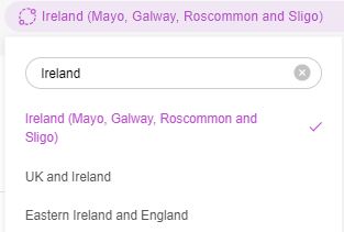
Another nice feature of the Genetic Groups at MyHeritage is that you don't have to be a member of a Genetic Group to filter your matches by those groups. Below I searched for Ireland.


If you then scroll down you'll see these specific Irish county Genetic Groups you can compare with. 


I'm finding the Genetic Group matches are generally matches from the very specific areas my family came from if the groups are narrow in scope. Below you can see some of the Genetic Groups are broad and some are narrow. Using the narrow groups does narrow down strong matches from the specific areas our ancestors came from. 


My Kapple/Kurta family lived in the Austro-Hungarian border area as you see in the above Genetic Group Austria (Burgenland) and Hungary (Vas) group we belong to at MyHeritage. Below you can see when I filter matches by this Genetic Group an Austrian match shows up in the match list next to someone currently living in Hungary. You see the Austrian and Hungarian flags representing the matches ethnicity. This demonstrates that these matches are living in a very specific location associated with my family.


The Ireland (Mayo, Galway, Roscommon and Sligo Genetic Group filter brings up 505 matches. If I filter by Irish ethnicity I get 4,489 matches. Filtering by people from Ireland  brings up 250 matches and is also a wonderful filter. 

The 505 Genetic group matches can be sorted by largest segment etc. I mainly look at the high to medium confidence matches. I only look at low confidence matches who share a specific surname or place. 

You can apply more than one filter. Applying the filter that shows matches from Ireland along with Genetic Group matches whittles down the 505 Genetic Group matches to 81. Practically all these matches are from the specific area my family is from in Eastern Galway and Southern County Mayo. 


I'm using the segment data from the matches I'm finding, who share the same specific places and surnames associated with my family, to build a chromosome map for myself , and relatives who tested. 


If there was a similar Genetic Group filter at 23andMe it would also help me to collect segments and build out my segment map. A filter like this at AncestryDNA wouldn't help me build my segment map, they don't provide segment data, but it would help to narrow down matches. 

MyHeritage DNA has all of the best features, great filters, trees, and segment data. It would be nice if every company had the same great features. 


Thursday, February 3, 2022

A Case Study in Irish House & Land Records

 A couple weeks ago I discovered an old photo posted at Ancestry.com of a house I looked at on my visit in 2019. This house is on the land of Patrick Mullen who was born about 1797, and died in May 1887 in Pollaturick, Milltown, Co. Galway, Ireland. This Patrick Mullen is my 3rd great-grandfather. 

When I visited the family townland of Pollaturick in 2019 I spoke with a couple neighbors who agreed that Michael Mullen, one of Patrick's sons, lived in the house that was in the photo I found at Ancestry. The house is still there but is now empty. I wondered if that was a house built by his father, Patrick, because for many years there was only one house on the land in that general area, according to ordnance maps.  

I remembered I had overlaid a recent map showing the current house over an 1839 ordnance map. The map shows a house behind the current house. This made me wonder if the house sitting on the property was the same house but the 1839 map is incorrect? 

This also brought up something I didn't consider. My ancestor Patrick Mullen Jr. married in 1880 and continued to live on the family land while his father and sister Bridget, and brother Michael, were living on the property.. Did they live in the same house?  In Jan 1887 Michael Mullen married. Did he build the house still standing on the property around that year or did he take over his father Patrick's house after his death in May of that year?

There currently are two houses on the Patrick Mullen Sr. property. A concrete house on the property was thought by neighbors to belong to descendants of Patrick Mullen Jr., my 2nd great-grandfather.  When it was built is unknown, but this fact seemed to suggest the Patrick and Michael Mullen brothers lived in different houses, and these houses referred to above were the two houses. 

I decided to do more research on the plot originally owned by Patrick Mullen Sr. because of the questions that now occurred to me.  

Goals of research

  • Who built the two houses now on the property? 
  • When were they built?
  • Who lived in each of the houses through the years
  • How was the land divided between Michael and Patrick after their father died?

Records used to answer these questions

  • Griffith's Valuation 
  • OSI Maps (Ordnance Survey Ireland)
  • Revision a.k.a Canceled books
  • Deeds from the Dublin Registry of Deeds (accessed at FamilySearch.org online) 
  • Land folios
  • 1901 and 1911 Censuses Ireland 

The houses in question

The house below appears to be constructed of stone? The question is when was it built, and who built it? Michael Mullen and his descendants lived in the house, but the question is did his father build it or did he?


This house is concrete. Probably built by someone in the Patrick Mullen and Mary Huane line, but when and by whom is unknown.


Pollaturick townland map

Map of the Pollaturick townland with the valuation lot numbers. 


Research in records begins

I consulted Griffith's valuation again to confirm the map number and number of acres in order to verify I was looking at the correct property on the ordnance maps, and that this was the same property later owned by his sons. The valuation was created for tax collection purposes. The list I looked at was created in the 1850s. It's not the original handwritten list but instead a printed version that was created for the appeals process. After the valuation was complete people, and organizations, could come forward with a  dispute or correction to the valuations. 

A great YouTube video explaining how to research land records using Griffith's Valuation records is 
Creating Connections Webinar Playback August 2020 Griffith Valuations.

Before the valuation could be made maps of properties to be valued for tax purposes had to be created. The military conducted the land survey in the 1830s and 1840s.

The first map showing a house on our Pollaturick lot 1 was produced in 1839. I overlaid the map again on a modern map using the GeoHive National Townland and Historical Map Viewer. The drawing of the house is fairly far from the current house on the property. 


I decided to test the theory that the house currently on the property is the same house as the one captured in 1839, even though the overlaid images don't match exactly. I overlaid the old and new images at known ancient building sites, like Glendalough. I discovered that the overlays could be off sometimes substantially. They were generally a little closer than the image is above, though.. 

The house still standing appears to be newer than 1839, however. I believe it may have had a concrete roof with thatching over it?

I couldn't determine, however, this absolutely isn't a modernized version of the older house. 

I noticed some more maps were at the GeoHive map viewer I hadn't seen before. The 1893 ordnance survey map showed some new buildings. Two buildings now appear behind the house still on the property. The larger of the two facing in the same direction could have been a house with outbuildings attached?


.
Does the possible house outbuilding combo line up with the house location in 1839?

Below is an overlay of the 1839 ordnance map with the 1893 map. The buildings appear to be side by side. The north walls of these buildings appear to line up . Since the newer building appears to touch the old house this building could include the 1839 house?


There is another ordnance map from 1913 which is basically the same as the one above. It does seem to include a building, said to be an old house, it may be what looks like an extension on the possible house combination out building on the 1913 map. It seems to be south and to the left of the larger building. The 1913 map seems to sometimes attach out buildings that weren't attached. Just because close buildings appear attached in 1913 doesn't mean they were.


Below is a photo of the building that may have been a house. It may have been in ruins in 1893 and was left off that survey. It's facing in the wrong direction to be the 1830s house. The way this building was constructed makes it look quite old. 


The cart house that is currently in ruins is also left off the 1893 map, but is included in the 1913 map. It may have been built after 1913 or just not included?


One thing jumped out at me when examining the maps is the fact the second house on the property isn't on either the 1893 or 1913 maps? It's a prefabricated concrete house so I figured it wasn't as old as the other house. In the image below you don't see a drawing of the crosshatched building when you overlay images (the crosshatches mean the building had a roof). There are buildings showing up on a neighbors property. These kinds of houses were built in the late 19th and into the 20th century. If the Patrick and Michael Mullen families lived in separate houses before 1913 the concrete house wasn't one of them. 


We know now that none of the families lived in this house before 1913. The unidentified large building on the property most likely was part of the second house that would have been on the property earlier.

What do the Censuses tell us?

According to the 1901 and 1911 Censuses for Ireland both of the Patrick Mullen Sr.'s sons, Patrick and Michael, were living in the townland of Pollaturick. I compared the buildings in Pollaturick on the maps with the census information. I don't see a property that isn't associated with a family on the census. The revision books don't show either brother as head of household on another landholding. 

In 1901 the brothers Michael and Patrick are described as living in a house with 3 front windows with 3 rooms, and 2 out buildings. The older house still standing on the property has 3 windows in the front. The newer concrete house only has 2. 

In 1911 the brothers were still living in houses by the same description but they both state they have 5 out buildings now. Even if there are two houses on the property at the time I believe the brothers shared some of the farm buildings. 

According to the 1911 Census both brothers had the following farm buildings: a cow house, piggery, a fowl house, and barn. Two building descriptions are different however. If the list is correct Patrick has a cart house, and Michael had a stable. 


The 1911 Census also states the men are living in separate houses. Does this mean they were? Probably but I can't confirm that. It does point to one of the other buildings on the ordinance survey being a house. 


Deeds

In 1901 Patrick and Michael received deeds to their father's land. The 57 acres mentioned in the valuation was now split between the two brothers. Their father died in 1887 and likely had a lease for the property which they remained on after his death. As long as they paid the rent, which was usually due May 1st and November 1st, they were allowed to remain on the land. When land reforms allowed them to own this property they applied to do so and received title. The deeds say nothing about buildings on the property. 


Revision/Canceled books

The revision books were an extension of the valuation books. Updates were needed to Griffith's Valuation in order to record new owners of properties, and to update taxes due. These books are the most complete surviving record of the heads of households in the 19th and early 20th centuries. 

Oddly when Patrick Mullen Sr. died in 1887 there is no sign of his name being crossed out or other names added? The brothers had title to the property in 1901. It appears it wasn't until about 1910 that his name was crossed out and the property is shown as split. 


I'm not sure if the Patrick Mullen listed in the books after 1887 was supposed to be him, or was it his son? Patrick Jr. was older than Michael and may have inherited the lease? Or no one reported the change of the head of household?

There is no sign of a change in the value due to a 2nd house being built on the property until the land was split. Apparently there were two houses but that was never noted. 

What we can infer from the revision lists is the land was split up and not shared. I think the buildings were shared but not the land. If you look at the column with the description of the land lots, 1a was split into 1 Aa B Patrick's land, and 1 Ca D Michael's land. The capital letters represent the land being carved into those sections. Capital letters represent land lot sections. The lowercase letter represents the building on the property, the house. There should have been a notation for a 1a and 1b if there were two houses on the property. The land and property were surveyed in 1893 when the 2nd house would have been there. Not sure why this possible second house doesn't appear in the valuation books?


The brothers could have chosen to share all of section one in common and not broken the land up. If that were the case the entry would show two lower case letters bracketed. Here is an example, below. Lot 14 is shared by Catherine Greany and Bridget Lyons. They share 24 acres. They live in separate houses, a and b. Each of their houses has a slightly different value.  


Sometimes you'll see a first name in parentheses. These names were added when two men in a townland had the same names. They wanted to differentiate between men with the same names. The problem in my family is there were two Michaels in Pollaturick, uncle and nephew, and both of their father's were named Patrick. The nickname Pat may have been used by Patrick Jr. to differentiate him from his father in records. 


I haven't found a record stating whether Patrick Mullen Sr. informally divided the land between his sons or the division happened another way after his death? 

Division of the land

The wife of a cousin who had visited Pollaturick knew mutual cousins on the Huane side of the family who still lived in that townland. She contacted this family for me and asked about my Mullen family; that was back in 2006. This person said a cousin of mine still owned the family land there. I was under the impression this was a cousin descended from my great-great grandparents Patrick Mullen and Mary Huane. I didn't know until now that she was actually a granddaughter of Patrick Mullen and Mary Huane. She is still alive and turned 100 years old last June. Someone told me when I visited that someone connected with the land was in a nursing home, which is correct. She is in a nursing home.  

The cousin in Pollaturick said that this granddaughter of Patrick and Mary was the last Mullen owning land in Pollaturick. Technically that is true, her maiden name was Mullen, but descendants of Michael Mullen still own part of his property. 

I was able to make contact for the first time with a  3rd cousin once removed who is descended from Michael on Facebook after posting a query last week. They explained the family still own the older house on the property. 

I purchased a book called "Tracing Your Irish Ancestors Through Land Records: A Guide for Family Historians'', by Chris Paton. I found a link in the book to a site, https://www.landdirect.ie/, where you can purchase land folios. The folios contain a description of the property and the name of the owner or owners. The site has a map which you use to locate the property in order to find the correct folio. By clicking on the section of the property with the newer concrete house on it I was able to get the folio number for the property. The folio cost 5 euros to buy. The owner according to the folio is the  granddaughter of Patrick Mullen and Mary Huane. 

Clicking on a link called highlight all plans I was able to see how the Mullen land was divided. Oddly the sections aren't adjoining. I'm guessing the land wasn't equally good throughout the property, and they tried to divide the good and bad sections fairly.  

These are the sections that belonged to Patrick Mullen Jr: 


The sections below were Michael's. His family, apparently, only now owns the property the house sits on which is why there is a gap where the house sits, I believe. Correct me if I'm wrong? Otherwise the sections fit together like puzzle pieces. 


The land in other townlands that Michael and Patrick owned are listed in the folio for the granddaughter of Patrick Mullen. This is because this folio contains information from the old folio from 1901. The official notes state the description information came from folio GY1812 which was the folio number recorded on Patrick Mullen's 1901 deed. 


Takeaways from this research project

My Facebook newly found cousin provided some information about the house her family owns. She said it didn't have electricity until the 1970s. She confirmed what I thought, the window on the side of the house was for a loft room. When I visited the Bunratty Castle and Folk Park I noticed some of the houses had loft rooms. I was thinking at the time what a clever way to add rooms to a small space. 


Did I reach any of my goals?

I did discover how the Mullen land was divided between brothers Patrick and Michael. I learned the newer house on the property was built after 1913 and is currently owned by Patrick Mullen Jr. and Mary Huane's granddaughter. The older house was built before 1893, most likely, and is currently owned by the descendants of Michael Mullen through his daughter Mary Walsh's line. 

I haven't been able to find out exactly who built the houses on the Mullen property. I am leaning towards thinking there were two houses near one another, one belonging to Michael Mullen and the other to his brother Patrick Mullen. The Patrick Mullen house is no longer there. I don't know where their father lived in his final days? His daughter Bridget was present at his death in 1887. Were my great-great grandparents living in a house of their own or did they live with Patrick Sr.? Still don't know? I did discover buildings I didn't know were there by looking at the ordnance maps. 

If I'm ever able to return to Ireland I will visit the Registry of Deeds in Dublin where there might be additional information about the property and houses.